IKC Slide Show
 The IKC Slide Show is provided to the public as an educational resource covering many aspects of speleo-science. Included are several slides on geology, hydrology, biology, archeology and outreach; not to mention the unique management challenges associated with caves and karst.
An outline of the slide show may be gleaned from the series of links below (similar to the Table of Contents of a book). Each slide builds on the knowledge presented in previous slides, and for this reason the slide show is best paged through in sequence. But if you prefer, you can jump ahead to a particular chapter by clicking on any of these links.
Stratigraphy of Southern Indiana
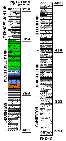 Through most of the Paleozoic Era, what is now Indiana was under the sea. Sediments were laid down and compressed to form the sandstones, limestones and shale layers that make up Indiana's bedrock. These layers represent a geologic record or timeline, with the older sediments underlying the more recent ones. The vertical scale of this stratigraphic map approximates the depth of the sedimentary rocks associated with each period.
 Most of the karsting occurs in the extensive, contiguous limestone layers deposited during the Mississippian period. These limestones are of exceptionally pure carbonate and have a total thickness of about 500 feet. These include (from older to younger): the Ramp Creek, Harrodsburg and Salem limestones of the Sanders Group; and the St Louis, St Genevieve and the Paoli limestones of the Blue River group. The strata containing these limestones are highlighted in blue. Underlying these limestones are the interbedded siltstones and shales of the Borden Group (orange). The younger Chester Series (green) consists of alternating sandstones, shales and limestones and are also more resistant to erosion and karst formation. However, a number of significant caves occur in the Beech Creek limestone, which ranges from 8 to 33 feet in depth (red).
The New Albany shale, underlying the Borden Group near the Devonian- Mississippian boundary, is a significant gas- producing formation laid down about 355 million years ago.
Physiography of Southern Indiana
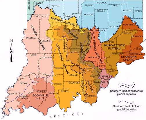 The sedimentary rocks laid down in the Paleozoic were subjected to erosional processes during the subsequent, Cenozoic Era. The generally humid climate of southern Indiana contributed greatly to these processes. Shales and sandstones are more impervious to erosion, so the areas where they outcrop tended to form uplands with deeply incised drainage valleys. Where limestones were exposed, much of it was dissolved and removed. Rivers became deeply entrenched, creating enough hydostratic head to encourage karst formation in these areas. At the boundaries between the stratigraphic layers, east-facing bluffs or escarpments formed (see map). The Springville Escarpment continues to retreat westward, leaving behind outliers -- sandstone capped remnants of the original uplands. All of these physiographic units extend well into present-day Kentucky.
A significant karst area also developed in the Devonian/ Silurian limestones of north-central and eastern Indiana. Present-day remnants of this karst topography may be seen in portions of the Muscatatuck Plateau; however, they lack the development of the central karst due to the few deeply incised master streams in this region.
Pleistocene Glaciations
During most of the last 1 billion years, the Earth had no permanent ice. But then, about 4 million years ago, the late Cenozoic ice age began. During an ice age, cyclic climate changes occur such that snowfalls do not completely melt the following summer. Ice sheets advance and retreat on temperate areas at intervals of about every 100,000 years. These shorter events are known as glaciations. 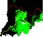 The last two glaciations severe enough to reach this part of the state were the Illinoian and the Wisconsinan. The Illinoian glaciation peaked ~220,000 years ago and its maximum southern extent is indicated by the yellow line at right. The Wisconsinan glaciation (red) peaked about 20,000 years ago.
These glaciations had a major impact on Indiana geology. Glacial sediments buried much of the karst present in the older limestones north of these glacial boundaries. Today, this buried karst supplies an important groundwater source for much of northern and eastern Indiana. Glacial boundaries and their meltwaters also defined the current course of the Ohio, Wabash, Muscatatuk, White, and other major rivers in Indiana.
For various reasons, the Mitchell Plateau was mostly spared glaciation. The green areas of the map show current exposed bedrock areas in the state. Where this coincides with the Blue River and Sanders group limestones shown in the previous slide, karst terrain displays its most extensive development.
Sinkholes
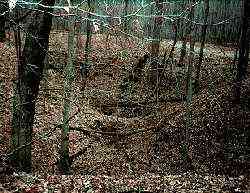 Solution caves are huge plumbing systems. Rainwater contains small amounts of nitric and carbonic acids. As these dilute acids seep through the cracks and bedding planes in the vadose zone of the bedrock, they slowly dissolve some of the limestone. Over time, the vertical crevices enlarge and literally funnel rainwater into the drainage system below, creating sinkholes. The sinkholes at left are found along a trail in a state park in Owen County.
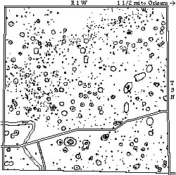 Sinkholes form early in the karsting process and are very common. This diagram -- of one section of land just southwest of Orleans, Indiana -- comes from field notes taken by Dr Clyde Mallott and Robert Schrock in 1929. In this one square mile, the two geologists counted 1022 sinkholes; the major karst areas of Indiana are estimated to contain 300,000 of them.
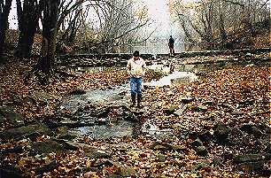
As you might imagine, few surface streams are found in heavily karsted areas such as the Mitchell Plain. The dry-bed of Lost River, which crosses the southwest corner of this section, carries only the overflow waters when heavy rains fill the subterranean passages.
Diagram courtesy Dr Clyde Mallott / Indiana Academy of Science.
Speleogenesis
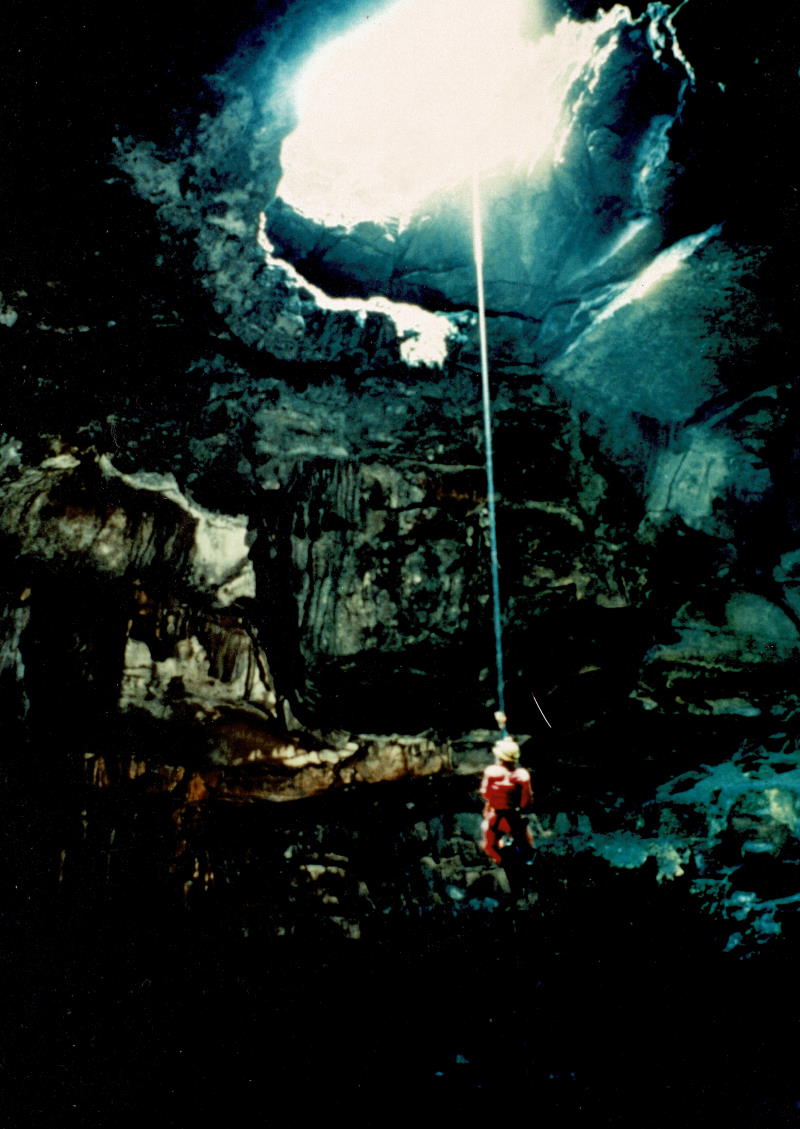
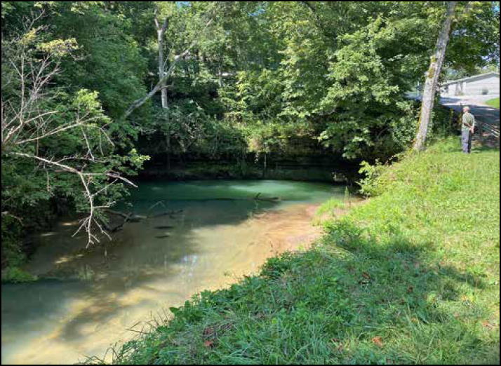 In time, vadose water seeping down through bedrock fissures reaches an area of saturation known as the phreatic zone or water table. Here, water moves laterally along bedding planes, slowly dissolving still more of the bedrock, and joining other waters until they eventually emerge at the surface in the form of a spring. This particularly well- developed spring is the Orangeville Rise; a National Natural Landmark that is also part of the Lost River system. Drainage from more than 40 square miles of land to the north and northeast finds its way through underground channels to resurface here, forming a "new" headwaters for Lost River.
Eventually, local surface streams deepen their valleys, lowering the water table and allowing phreatic passages to drain. Thus, most solution caves are abandoned spring water conduits. In this manner the submerged passage currently found at Orangeville will someday become the spring entrance to a cave. Such passages are characteristically circular or oval in cross section as limestone is dissolved on all surfaces.
From this point, the primary mechanism for enlarging the passage is erosion, although some dissolution still takes place. Sinkholes continue to funnel rainwater into the subterranean passage, and collapse of one or more of these sinkholes may provide new entry points. Bank erosion and down-cutting mechanisms within the cave may create meander loops or any of the other features commonly found in surface streams. A combination of phreatic followed by vadose action often creates passages with a “keyhole” cross section — a round-shaped passage at the top with a trench or “canyon” at the bottom.
The hardness of the rock, hydrostatic head, orientation of the original fissures, prevalence of vadose versus phreatic dissolution, and amount of subsequent erosion all determine the final structure of cave passages.
Speleothems
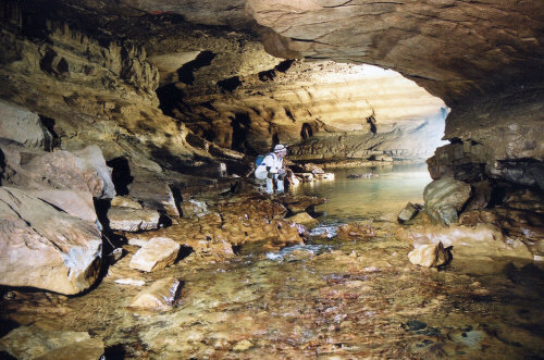
 In later stages of cave development, surface water containing dissolved limestone continues to be funneled into the cave system from above. As these waters emerge into the ventilated cave passage, the carbon dioxide is released.
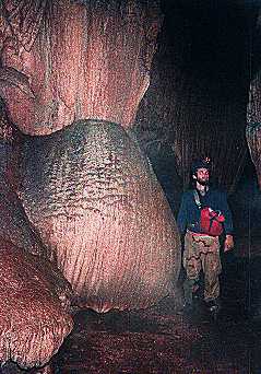
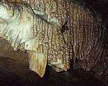
 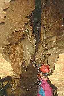 Calcite is preferentially deposited in areas where release of CO2 is facilitated -- creating the stalactites, stalagmites, and other fantastic formations we all enjoy in caves. Scientists call these formations speleothems. The massive deposits shown are found in a Lawrence County cave.
Once removed from the cave environment, speleothems lose their luster and much of their appeal. Cave vandals, in hopes of taking home a souvenir of their stay in a cave, may destroy in a moment what took thousands of years to create. Even the natural skin oils from cavers' hands inhibits futher deposition of limestone. The best way to enjoy speleothems is to "look -- but don't touch."
Other Karst Features
 There are many significant karst features besides caves, sinkholes and springs. These include:
- Karst Windows - collapse openings into existing cave passage
- Karst Valleys - distal dry valleys which carry storm waters only and have karst features in their floors
- Gulfs - large karst windows with steep sides and an alluviated floor
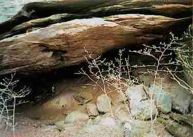
- Sinks - locations where surface streams lose water into subterranean passages (also known as swallow-holes), and
- Natural Bridges (rare).
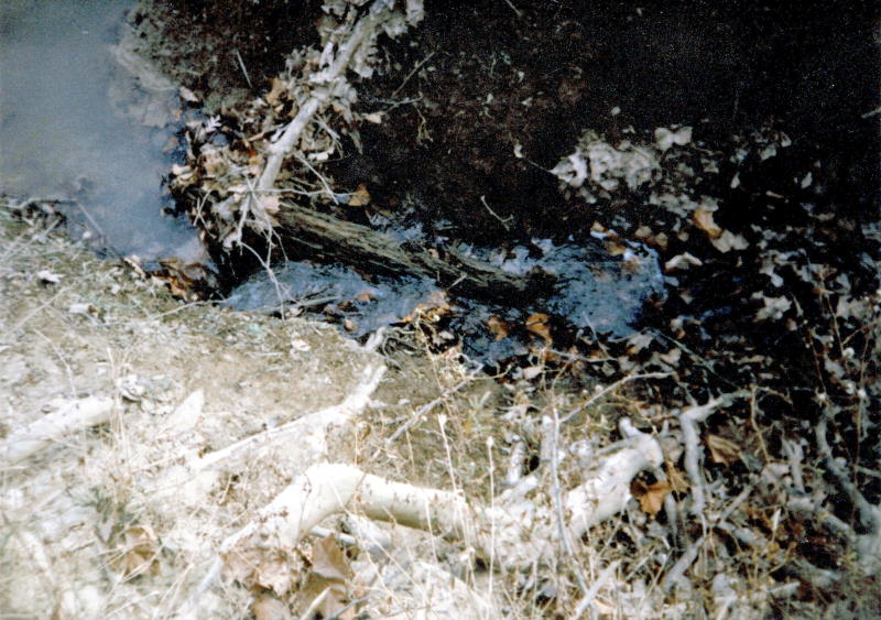
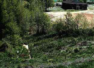
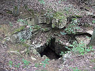
 The above image is an example of a small swallow-hole. A stream is flowing from left to right, quietly entering a subterranean passage. Often, a whole series of these swallow-holes will be present in the stream bed. During times of flood, upstream swallow-holes are inundated with flood waters and the stream will terminate in another swallow-hole further down the dry-bed. This particular swallow-hole is in Tincher Hollow, and is representative of karst valley features found through much of the Crawford Upland.
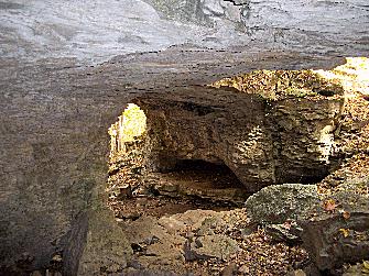
The karst feature shown at left is near the retreating mouth of a cave spring. Ceiling collapse at two locations has formed adjacent karst windows, with the original cave ceiling between them being left as natural bridges. Twin Bridges is downstream of Wolf Cave in Owen County, at the northern extremity of Trail 5 in McCormick's Creek State Park. Although rather interesting geologically, Wolf Cave consists of a single passage only 240 ft long.
Lapiés, Grikes and Terra Rosa
 When limestone is disintegrated by solutional processes, it leaves behind a clayey, residual soil known as terra rosa (Latin for "red earth"). Terra rosa is characteristic of much of the Mitchell Plain, where these processes have been taking place for hundreds of thousands of years.
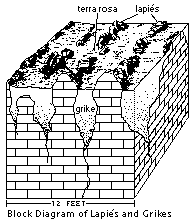
 Where erosion has removed the overlying soil , the limestone bedrock can be seen. On some of these surfaces and elsewhere in the near- surface limestone, joints are opened and widened into fissures known as grikes (see the diagram at left). The rounded, upward- projecting surfaces of the remaining limestone are known as lapiés.
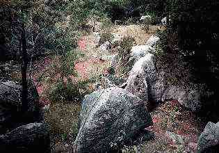
Pictured is a classic example of these solution features just west of the Monon railroad cut a few miles south of Bedford, Indiana. The features in this vicinity were the subject of a 1948 paper by geologist Preston McGrain for the Indiana Academy of Sciences. Note the color of the terra rosa soil. Similar features may be seen near the large quarry north of the town of Oolitic.
Diagram modified from R Powell / Indiana Geological Survey
Cave Life
 On first sight, caves show little sign of life. Although it's true that most plants cannot achieve a foothold in the complete darkness of caves; many animals, bacteria, and fungi have adapted to this environment and thrive on the organic material carried in by other animals, water and wind.
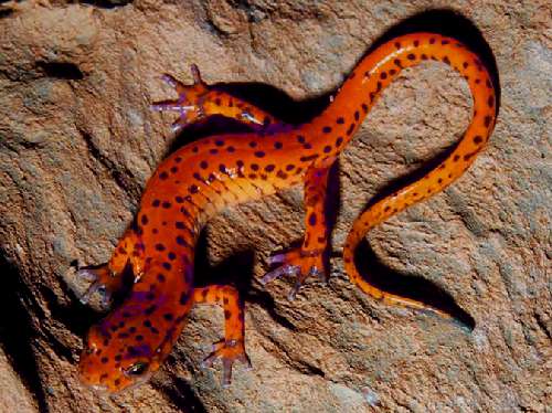
Pictured are two inhabitants of the "twilight zone" near cave entrances. The Spotted Cave Salamander (Eurycea lucifuga) is seen singly or in groups hanging to damp walls near cave entrances. They are typically 4-7 inches long, including the tail. Their presence deep in a cave indicates another entrance is nearby, although the entrance may not be large enough to admit a human. Although fairly common in Indiana, this salamander is listed as endangered in a number of other states.
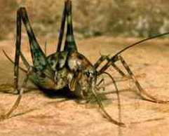 The Camel Cricket (Ceuthophilus stygius) appears intimidating in this photo, but rarely exceeds an inch in length and is entirely harmless. Camel crickets prefer to hang from the ceiling and, unlike field crickets, do not "chirp." This species is fairly plentiful and can be found outside of caves in just about any moist environment.
Cricket photo courtesy Dept of Entomology, Clemson University
Allegheny Woodrat (Neotoma magister)
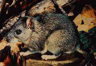 Like the camel cricket and cave salamander, the Allegheny Woodrat is an example of an Indiana trogloxene. The woodrat can do well in any cave-like environment, and is not restricted to caves. It is primarily nocturnal, and prefers to live in solitary dens. Woodrats build caches of berries, fruits, nuts, and vegetation; often preferring cedar foliage for their nests. They breed from late winter to late summer, with a gestation of about a month. Females may have two to three litters per year, averaging two young in each litter.
The Allegheny woodrat's range once stretched as far north as Owen County; but their range has been rapidly shrinking. The species has disappeared entirely from Connecticut and New York, and is threatened throughout much of its remaining range. The reason for the decline is unclear, but a leading theory involves the raccoon roundworm, a parasite that is often fatal to small mammals. In Indiana, the Allegheny woodrat is restricted to a handful of caves and rock shelters within a few miles of the Ohio River.
Photo courtesy S Johnson / Indiana Dept of Natural Resources
Indiana bat (Myotis sodalis)
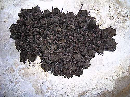 The insectivorous Indiana bat bears a strong resemblance to the more- common Little Brown bat (Myotis lucifugus) and wasn't initially recognized as a separate species. Although only slightly different in color, Indiana bats are easily identified by their tendency to form compact groups on horizontal cave ceilings (sodalis = social). A typical cluster, shown at right, contains about 300 bats per square foot.
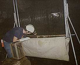
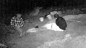
Due largely to this behavior, Indiana bats are very susceptible to flooding or other disturbances during hibernation. Repeated awakenings may cause significant depletion of the stored fat that is necessary to survive. Below, an IKC researcher is using a harp net to collect bats at a Greene County cave to measure how much weight was lost over the winter.
 In October, Indiana bats swarm at their hibernation sites; this activity accompanies mating. Fertilization does not occur until the female leaves the site the following March. In summer, males and females live apart from each other, with the females forming nursery colonies in hollow trees or under bark. A single pup is born in late June and the young become independent from their mothers in 4-5 weeks.
Indiana bats prefer colder hibernating conditions than most Indiana caves offer. The IKC manages two significant Indiana bat hibernacula in Monroe County. Members participate in a biennial census of the bats in Indiana caves, and have installed temperature monitors and prototype surveillance devices in the largest hibernacula. Although listed as endangered throughout its range, census figures indicate that populations in Indiana are steady or slightly increasing.
Harp net photo courtesy S Johnson / Indiana Dept of Natural Resources
Cave Invertebrates
 Over time, some cave-dwelling species adapt specifically for the cave environment. Since caves are dark, there is little advantage for these animals to develop pigmentation or eyes; so evolution of such species eliminates these unnecessary attributes. Such species are known as troglobites. Unlike the trogloxenes we've been discussing so far, most troglobites would have a difficult time surviving outside of a cave environment.
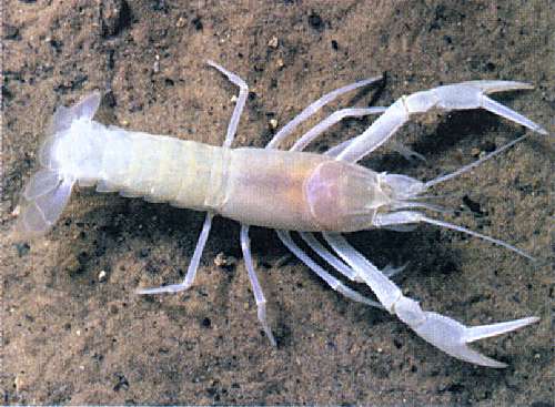
Troglobitic invertebrate species are not uncommon, but individual species usually aren't very widespread. The sightless cave crayfish pictured (Orconectes inermis) is one example. Although abundant in one cave managed by the IKC, this species is listed as threatened in Indiana. Its population is monitored for any effects of human visitation.
Hoosier Cavefish (Amblyopsis hoosieri)
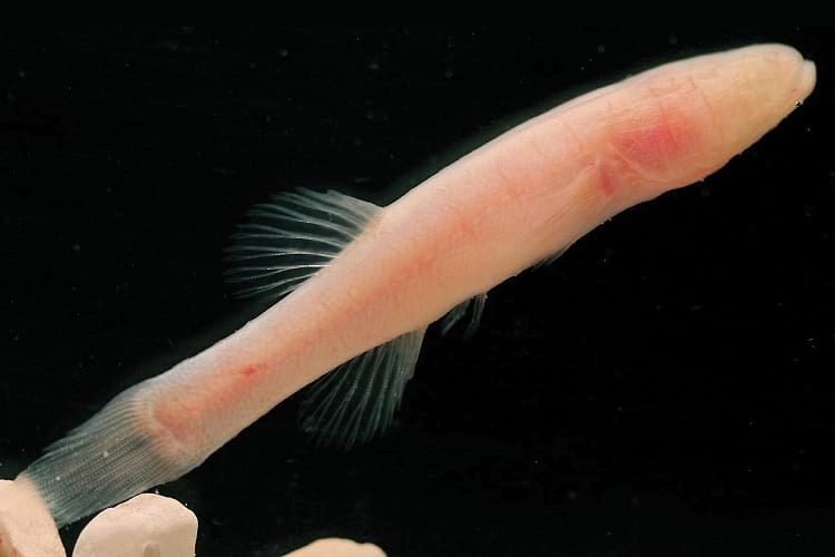 Completely blind, this hardy fish thrives in the dark environment of caves. Its range is restricted to a few dozen cave streams north of the Ohio River and south of the East Fork of the White River. Because of this restricted habitat, the Hoosier Cavefish is listed as an endangered species. Unlike surface fish, this cavefish lacks pigmentation — its pinkish color is due to the hemoglobin in its blood.
The Hoosier Cavefish received a great deal of press when State Road 37 was widened to four lanes between Bedford and Mitchell, Indiana. Several fish were found in a passage opened by construction, and were released in nearby Bluespring Caverns. The alarm that went through the environmental community eventually resulted in a Memorandum of Understanding between the Indiana Dept of Transportation and several other state agencies to help ensure that future road work is performed in a more karst- friendly manner.
Closely related to the Northern Cavefish found in Mammoth Cave, the Hoosier Cavefish was not recognized as a separate species until 2014. Photo courtesy Wikimedia Commons
Cave Paleontology
 The significant animals found in a cave are not necessarily the living ones. Caves provide a uniform temperature and humidity, and flood waters entering caves will occasionally wash in plant and animal remains. Pit caves may also trap animals that wander too close to the edge. Because of these characteristics, caves can provide a uniquely beneficial environment for preservation of fossil plant and animal species.
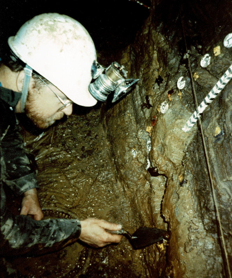
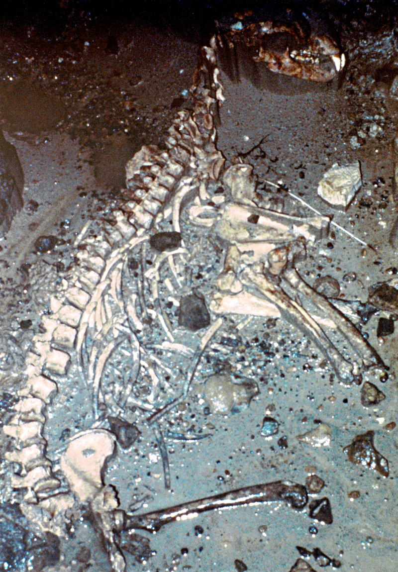 These photos show a paleontological dig in a Crawford county cave. At left, a 25,000 year old mixture of flat- headed peccary and dire wolf remains were exposed by Indiana State Museum paleobiologists five feet below the surface of a clay bank in a lower room. Their age puts these remains firmly in the late Pleistocene. At right is a black bear skeleton of similar age, preserved in sands at the bottom of a 90-foot vertical shaft. Such fully- articulated skeletons are quite rare; yet it is not uncommon to find trace fossils, such as bear wallows, in Indiana caves.
If you should encounter bones or other remains that appear to be old, do not attempt to remove them yourself! The location and orientation of each must be carefully documented to preserve their scientific value. Instead, please contact the Indiana State Museum at 317-232-1637 and report your findings. If you are unsure, the IKC can help put you in touch with the appropriate people.
Photos courtesy of R Richards / Indiana State Museum.
Cave Archeology
 Throughout history, Man has been drawn by the lure of caves. In the past, caves were used for shelter, religious rites, and acquisition of decorative minerals. This is particularly true of Wyandotte Cave, a state-owned property with considerable archeological significance. However, signs of human habitation are occasionally found in other Indiana caves as well.
Pictured is a rock shelter in Crawford county known for its content of Native American artifacts. This site was the subject of an archeological dig in mid- 1997. Research focused on defining the level and degree of prehistoric occupation. Although extensively damaged, excavations revealed intact artifactual deposits left by Native Americans of the Early Archaic period (8,000-5,500 BC). Angie Krieger, archeologist for the USDA Forest Service, can be seen standing in the entrance; giving some idea of the scale of this photograph. The photo below shows researchers from Ball State University conducting excavations.
Unfortunately, this site has also seen a great deal of looting over the years, and much of the potential for scientific discovery has been lost. Like paleontological remains, artifacts are best collected only by trained personnel. These non-renewable resources are part of our nation's heritage and have great potential to teach us about our past. If you should find signs of ancient human visitation in caves, please leave everything as you found it and contact either the Indiana State Museum or the IKC for assistance. Photos courtesy USDA Forest Service and Ball State University |
Vandalism...
 Most organized cavers are aware of the sensitive nature of caves and take measures to minimize their impact. Unfortunately, not all cave visitors are conscientious. Some maliciously break formations or paint slogans and obscenities on the cave walls. Others leave candy wrappers, beer cans, carbide waste, and other debris in the cave. Even careful, well-trained cavers eventually have an impact on heavily visited caves.
Graffiti is a very common problem. Some people might feel the sign at left is justified to help cavers find the way out from a confusing junction room. But eventually, someone comes along and paints such signs at ALL the room exits, leaving the correct one ineffective. In the long run, these "helpful" signs just encourage others to vandalize the cave.  When necessary, experienced cavers use flagging tape to mark their route -- and remove it on their way out.
The thoughtless actions of cave vandals sometimes prove to be their own undoing. It's not unusual for a vandal to paint his own name on the wall, sign a cave register, or otherwise leave evidence that helps track him down. In 1993, the first successful prosecution of damage to a non-commercial cave under the Indiana Cave Protection Act occurred when trespassers entered a cave in Washington County and wrote their names and references to their high school.
...and More Vandalism
 Graffiti is only one type of damage inconsiderate visitors cause. Pictured are two other examples.
The slide at right shows the result of formation mining. Large pieces of this once- beautiful flowstone drapery have been removed by visitors looking for souvenirs or hoping to make onyx figurines. Just to the right of center, a railroad spike was driven into the flowstone and left to rust. We can assume that the rest of the flowstone mass was broken off and removed by similar means. Even in a cave that is actively developing formations, it can take thousands of years for nature to repair this kind of damage.

Another example, perhaps more distressing, is given at left. This photo shows the decayed remains of an endangered Indiana bat. Vandals dug under a locked, protective fence to gain access to a cave that was closed for bat hibernation, ignoring clear signs at the entrance. The vandals then proceeded to shoot a number of the clustered bats with a B-B gun. One has to wonder at the mentality of someone who would go to such lengths -- risking criminal prosecution -- to accomplish this objective.
Cave Restoration
 When cave damage becomes excessive, the IKC and local grottos may collaborate in an attempt to restore a cave to its original condition.
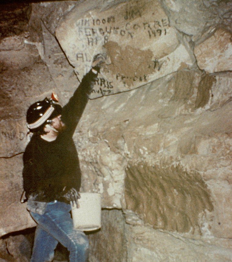
Restoration techniques vary widely. One of the most common approaches, shown in the photo, is brown-washing; in which a mud slurry is applied over the offending paint. When dry, the wall reverts to something approaching its previous appearance. Wire brushes are also occasionally 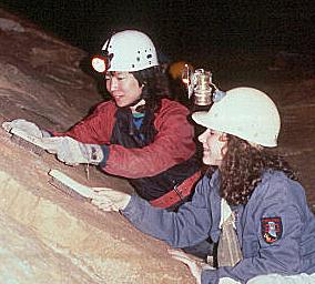 used to remove the graffiti, but they damage the wall surface and aren't suitable for use on cave formations. Commercial cave owners may use high pressure washers to remove years of mud and grime. Spent carbide, cans, bottles and other trash are collected in canvas and zip-lock bags and removed. Many responsible cavers will routinely pack a trash bag and remove debris on every caving trip. If the pieces can be found, broken speleothems may be repaired using water-resistant epoxy cement -- levers and/or pins hold the pieces in place until the adhesive sets. In time, new calcite is deposited to hide the repair.
Obviously, the best approach to cave restoration is to avoid damage from the outset.
Cave Gating
 It sometimes happens that cave visitation must be restricted due to run-away vandalism or sensitive biological resources. The preferred means to accomplish this objective is to spread the word why access is limited and provide a mechanism for controlled, legitimate access. However, some cavers refuse to cooperate. When all attempts to achieve appropriate management objectives fail, or landowner relations require access restrictions, cave gating becomes a necessary evil.
Pictured at upper left is the first gate installed by the IKC. At that time, gating was a controversial topic in the caver community. This gate was repeatedly vandalized and some bad feelings resulted. Yet in the intervening years, most cavers have come to recognize the merits of protecting cave resources from those who are disrespectful. 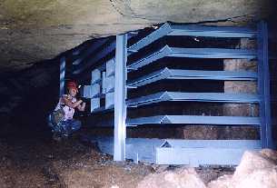 The IKC also established a grotto liaison policy that helped restore the trust of organized cavers.
Cave gating isn't nearly the issue that it was in the mid-80s. Still, an improper gate can restrict the passage of air, animals and nutrients into the cave system and may damage the very resource it was designed to protect. Although gate design has improved substantially (a gate constructed in 1997 is shown at right), cave gating remains a management approach that should be avoided whenever possible.
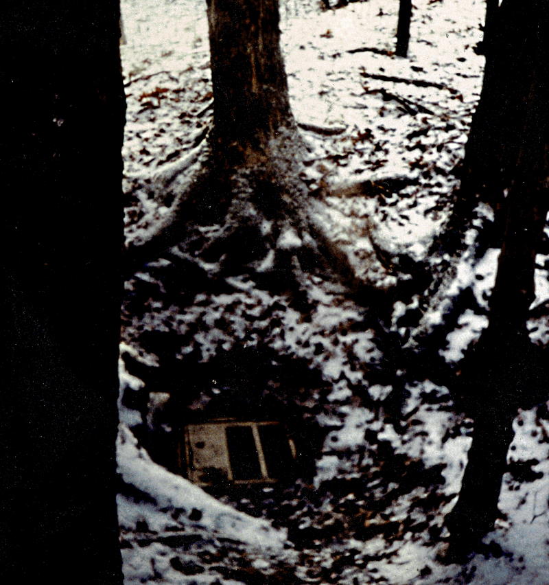
Sinkhole Dumping
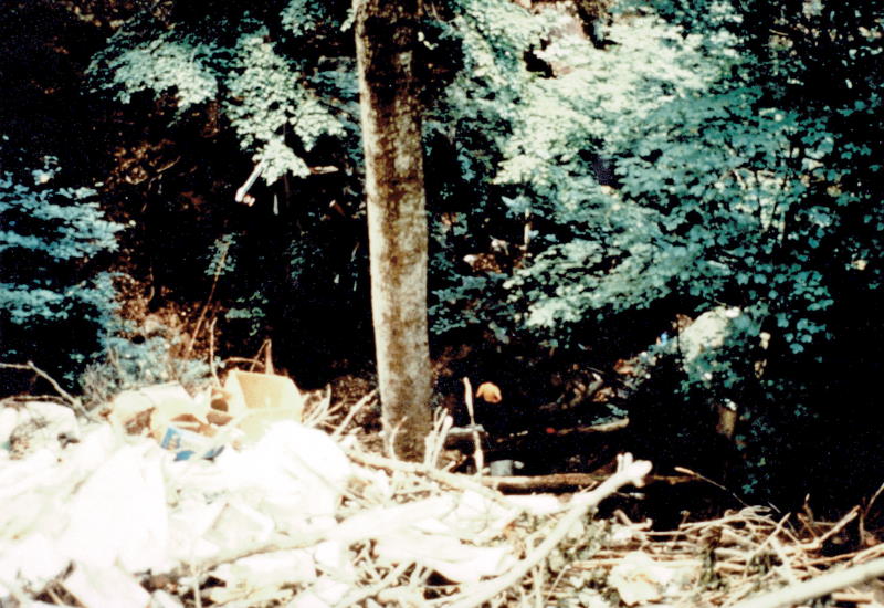 Many of the hazards facing karst today come from outside of the cave system. Sinkhole dumping is an especially pernicious problem. Sinkholes provide a "convenient" place to deposit trash, rather than paying to have it hauled away. Many people obtain their drinking water from residential wells, and may unknowingly contaminate the very resource their livelihood depends on -- not to mention the damage to the cave life below. Large feedlots and septic systems in karstlands are also problematic as coliform bacteria find their way into the water supply.
The photo at upper right is but one example. This sinkhole is 60' deep, but is half-filled with trash and has several complete cars tossed in for good measure. 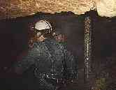 The water percolating through this garbage enters an extensive cave system, part of which is commercialized, eventually discharging into a swimming lake at a state recreation area. Compare this photo with the one at left; in which a well casing penetrates a cave. Cave water is being drawn from this well for residential use with very little filtration.
In 1996, the IKC worked in conjunction with The Nature Conservancy, county Soil and Water Conservation Districts, and other interested organizations to create an anti-dumping flyer. These educational flyers continue to be distributed to thousands of karst landowners in Indiana and surrounding states to discourage inappropriate use of sinkholes.
Development in Karstlands
 More and more, the hazards facing cave systems lie not in the individual actions of adjacent landowners or vandals, but in residential and commercial development. Karst is particularly vulnerable to damage from urban sprawl. Erosion during construction silts up cave passage, and road salt or leaking underground storage tanks pollute cave waters. County planners sometimes cut corners when faced with the expense of extending sewage treatment facilities. Drilling activities may penetrate caves, introducing foreign materials into the cave environment. Since these impacts are underground, all too often little thought is given to them.
Developers were allowed to construct the building at top right on the side of a blind valley which feeds rainwater into a large cave system (the entrance is near the sign at lower left). Mud and silt deposits are clearly seen on the valley floor, and more silt washed into this cave with every rainfall. This situation continued for months without the developers making any attempt at erosion control.
 The other photos on this page came from another large system in Lawrence county. This cave once contained a significant population of blind cave fish. Unfortunately, a leaking underground storage tank from a local service station introduced gasoline into the system. The status of the cave fish is unknown.
These are clearly examples of gross neglect, but in other cases it can be difficult for developers to determine if sensitive resources exist in the vicinity. Cave location data is a key ingredient to ensure their protection. The Indiana Cave Survey has the most extensive database of karst features in the state. The IKC is working closely with the ICS, The Nature Conservancy, and state and federal agencies; developing ways to share this information "as needed" while retaining its confidentiality. The IKC also worked to strengthen gas drilling permit requirements in an attempt to reduce the chance that wells will penetrate known cave passage.
Cave photos courtesy S Frushour / Indiana Cave Survey
Landowner Relations
 The vast majority of karst properties in Indiana are on private land. For continued access to these properties, it is essential that cavers maintain a level of trust and goodwill with these cave owners. The owners do not have to allow access to their resources and it's very important that we let them know how much we appreciate their tolerance. Many of the activities of the IKC are related to this objective.
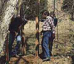
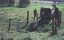
These images depict two workdays that the IKC has held to assist cave landowners. The owner of the first cave, located in Orange County, was allowing visitation; but traffic over her fence to get to the cave was causing damage. The photo shows an IKC workday at her property to both repair the fence and install a stile at our own expense so the problem would not recur.
 The owner of the property at left was very cooperative with cavers during the 1992 NSS Convention in Salem, Indiana -- allowing a number of trips to visit two pits on his land, one of them nicely decorated. Unfortunately, a few cavers tracked mud on pristine formations in this pit. The IKC held another workday to clean up the formations and install fencing around the pits to alleviate fears that his cattle would wander into them. In this case, the landowner and his son supplied the materials and a great deal of assistance.
These workdays are typical of the occasional activities that the IKC engages in to help balance karst protection with the interests of cavers and landowners.
Land Acquisition and Management
|
Property purchased by the IKC |
From the previous slides, it's apparent that caves and karst offer unique management challenges. Many landowners are not prepared to deal with endangered species; unusual geology and hydrology; or the occasional, irresponsible spelunker. Thus, from its inception, the IKC has sought opportunities to acquire management rights to a number of karst features. In so doing, the IKC frees landowners from these difficulties while allowing compatible, carefully monitored use of the karst resources for legitimate scientific study and recreation. |
|---|---|
|
Property managed by lease |
Initially, the IKC's land management consisted of leasing agreements. For a nominal fee (usually $5 or less per year), the IKC has acquired management rights to several significant caves in Indiana. However -- be it through change of residence, adverse incidents, or death -- the relationship with landowners can and often does change. Therefore, leasing agreements do not ensure protection of the resources in perpetuity. To remedy this, in recent years the IKC has more actively sought opportunities to purchase karst properties outright. |
|
Property managed by easement |
Another opportunity for protection of karst properties is the conservation easement. If a landowner wants to restrict or prohibit activities that are karst unfriendly, usage rights may be donated to the Conservancy. These are recorded with the deed, and remain with the property when ownership changes hands. The IKC thus retains the right to protect the property according to the original landowner's wishes, even after his death. Landowners also receive relief of property taxes while retaining ownership and use of their land within the covenants of the easement. |
Karst landowners have been very happy with the active management practices of the IKC. In fact, no collaborative venture between the IKC and a karst landowner has ever been terminated due to management issues. The IKC's special management touch, coupled with sensitivity to the landowner's needs, invariably results in a win-win situation.
Public Outreach
 Pictured are a few examples of the public outreach activities of the IKC. Our Special Reprint Series consists of eight publications (as of mid-1997) of particular historical or scientific interest. In many cases, the books or journals in which the material originally appeared are now out of print and could not be obtained otherwise. Topics in the reprint series range from biology, geology, archeology, paleontology, hydrology, and even a bibliography of other scientific resources.
 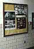 The photo at right shows the fourth reprint in the series; a cave-related chapter from Gleanings from Nature by Blatchley. Originally published in 1899, this particular chapter provided one of the first descriptions of the animals living in and around the caves in southern Indiana. These older works make for very entertaining reading, reflecting a time when scientists shared an awe and respect for their area of study; something rarely found in current, data-driven scientific works.
The IKC also occasionally distributes posters or other informative materials to their membership for educational use. The photo at left shows some posters provided by the IKC -- discussing groundwater protection and cave life -- on display at an elementary school northeast of Indianapolis.
Other IKC-sponsored public outreach activities include:
- The IKC Update, our newsletter and main source of information on IKC activities.
- The Indiana Cave Symposium, an annual educational event jointly sponsored by the IKC and the Indiana Cave Survey.
- Earth Day Indiana and other such events, where the general public may view our display, ask questions, and obtain informative brochures.
- Member-led presentations to scout troops, clubs and other interested parties.
- IKC promotional items such as hats, T-shirts and polo shirts with the IKC logo; which foster a sense of pride and identification with the organization.
- The IKC web page and this slide show!
For more discussion of IKC activities, please view the separate page devoted to that topic.
The End??
|
We hope you enjoyed our slide show!Please check back periodically.We may have a few more for you on your next visit.
The IKC recommends |