Stratigraphy of Southern Indiana
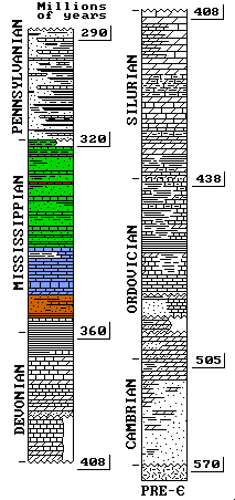 Through most of the Paleozoic Era, what is now Indiana was under the sea. Sediments were laid down and compressed to form the sandstones, limestones and shale layers that make up Indiana's bedrock. These layers represent a geologic record or timeline, with the older sediments underlying the more recent ones. The vertical scale of this stratigraphic map approximates the depth of the sedimentary rocks associated with each period.
 Most of the karsting occurs in the extensive, contiguous limestone layers deposited during the Mississippian period. These limestones are of exceptionally pure carbonate and have a total thickness of about 500 feet. These include (from older to younger): the Ramp Creek, Harrodsburg and Salem limestones of the Sanders Group; and the St Louis, St Genevieve and the Paoli limestones of the Blue River group. The strata containing these limestones are highlighted in blue. Underlying these limestones are the interbedded siltstones and shales of the Borden Group (orange). The younger Chester Series (green) consists of alternating sandstones, shales and limestones and are also more resistant to erosion and karst formation. However, a number of significant caves occur in the Beech Creek limestone, which ranges from 8 to 33 feet in depth (red).
The New Albany shale, underlying the Borden Group near the Devonian- Mississippian boundary, is a significant gas- producing formation laid down about 355 million years ago.